UXO/Mine Detection and Subsurface Utility Mapping

Unlocking Subsurface Insights with Advanced Drone Technology

GeoSecure Strategies is excited to introduce our latest service: Subsurface Mapping and cutting edge technology, which leverages autonomous drones equipped with advanced sensors to provide detailed insights into the subsurface, enhancing safety, efficiency, and accuracy across various projects

Unleashing the Power of Aerial Technology for Subsurface Exploration.

Our innovative services provide a new dimension in subsurface mapping and analysis, offering detailed insights into the underground environment. This cutting-edge technology is revolutionising industries that rely on subsurface analysis, providing unprecedented safety and efficiency. By integrating sophisticated sensors and algorithms, our technology is able to collect high-precision data, which can be used for elevation models, utility mapping, and infrastructure planning.

This service is particularly beneficial for construction, oil and gas, and environmental projects.

Drone-Powered Pipeline Surveys for the Oil Sector

  • Expertise and Experience: Our team of seasoned professionals has over 30 years of experience in high-risk environments, ensuring reliable and accurate results.
  • Advanced Technology: Leverage state-of-the-art drone technology and sensors for precise and efficient data collection.
  • Global Reach: With operations spanning the Middle East, Africa, Europe, the Americas, and Central Asia, we offer unparalleled knowledge of diverse risk landscapes.
  • Customised Solutions: Tailored subsurface mapping services to meet the unique needs of your project, ensuring optimal results.

Contact us today to learn more about how our Subsurface Mapping and Analysis with Drones can enhance your projects and provide valuable insights into the subsurface.

Rapid Coverage

Survey vast areas efficiently with our advanced drone technology, covering 8-10 hectares per day for swift project completion and minimal operational delays.

Enhanced Safety

Minimise personnel exposure to hazardous environments by reducing the number of ground operators required, ensuring safer operations without compromising survey quality.

Superior Precision

Achieve 98% survey accuracy through state-of-the-art drone technology, significantly reducing human error and delivering reliable, consistent results for informed decision-making.

Advanced UXO Detection

Utilising state-of-the-art geophysical survey methods and AI-driven analytics to identify and map unexploded ordnance with precision, ensuring safe site development and risk mitigation.

Comprehensive Mine Detection

Expert subsurface scanning technology capable of detecting and mapping mines up to 8 meters deep, providing crucial intelligence for safe site clearance and development.

Applications and Benefits

  • Construction and Infrastructure: Quickly identify buried utilities, underground structures, and potential hazards before excavation begins. This reduces the risk of accidents and ensures precise planning
  • Environmental Assessments: Detect and map environmental contamination, providing valuable data for remediation efforts. Drones equipped with sensors can identify buried metal objects and other anomalies with remarkable accuracy
  • Resource Exploration: Efficiently locate and map extractable resources, such as minerals and oil and gas pipelines, using magnetic and electromagnetic surveys.
  • Archaeological Research: Discover hidden archaeological sites and structures without invasive excavation, preserving historical sites.

Advanced Sensing Technologies

  • Thermal Imaging: Detect subtle temperature differences on the ground surface, indicating the presence of buried metal objects. This is particularly effective during early morning or late evening when temperature contrasts are most pronounced.
  • Magnetic Surveys: Utilise highly sensitive magnetometers to measure variations in the Earth’s magnetic field caused by ferrous metals beneath the surface. This method is ideal for locating larger buried objects or structures.
  • Electromagnetic Methods: Employ electromagnetic sensors, such as metal detectors and conductivity meters, to transmit and measure responses from induced electrical currents in buried metal objects.
  • Ground-Penetrating Radar (GPR): Create detailed 3D images of the subsurface by sending high-frequency radio waves into the ground and analysing the reflected signals. GPR excels at providing precise depth and shape information.

Efficient Data Collection and Analysis

  • Ultra-low Altitude Surveys: Conduct surveys at 0.5 to 5 meters above ground level for high-resolution data collection.
  • Real-Time Data Processing: Utilise AI-driven software to process and analyse data in real-time, providing actionable insights quickly.
  • Customisable Flight Plans: Design flight paths to cover large areas efficiently, ensuring comprehensive data collection.

Enhanced Capabilities for Subsurface Analysis

  • High-Definition Imaging: Capture clear, high-resolution images that reveal detailed underground features.
  • Multi-Sensor Integration: Combine data from various sensors for a comprehensive subsurface profile.
  • Automated Data Analysis: Leverage AI to automate the analysis process, reducing manual workload and increasing efficiency.
  • Rapid Deployment: Quickly mobilise drones to the site for immediate data collection and analysis.
  • Seamless Integration: Easily integrate drone-collected data with existing systems and workflows.

Precision Underground Utility Mapping & Infrastructure Detection

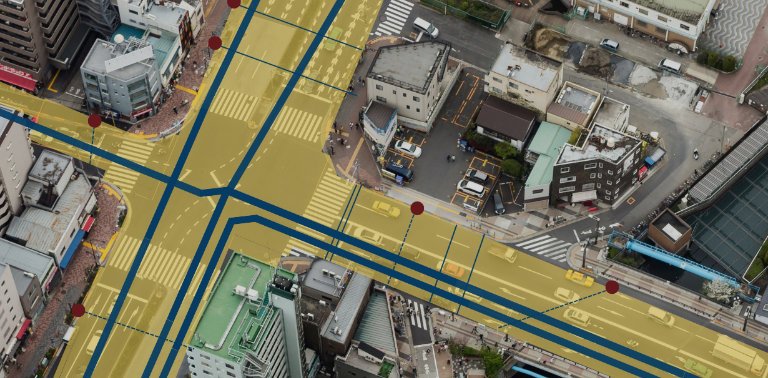
GeoSecure Strategies employs cutting-edge subsurface detection technology to provide comprehensive underground utility mapping services, ensuring precise infrastructure location and risk mitigation. Our advanced mapping capabilities deliver detailed insights up to 8 meters below ground, supporting safe and efficient project execution.

  • Real-time mapping and visualization of underground utilities including water pipes, electrical cables, telecommunications lines, and gas infrastructure
  • High-precision depth and location data to prevent costly utility strikes and project delays
  • Advanced AI-driven analytics for complex infrastructure identification and documentation
  • Detailed 3D modeling capabilities for enhanced project planning and risk assessment
  • Integration with existing GIS and CAD systems for seamless workflow incorporation
  • Comprehensive reporting with annotated maps, depth measurements, and utility classification

Why Choose GeoSecure Strategies for Subsurface Mapping?

Optimal Pipeline Pathways with GeoSecure's Technology.

GeoSecure Strategies, in partnership with leading experts in subsurface detection technology, delivers comprehensive solutions for mine detection, unexploded ordnance (UXO) identification, and interactive mapping of underground utilities up to 8 meters deep. Using cutting-edge geophysical survey methods, advanced AI-driven analytics, and state-of-the-art ground-penetrating technology, we provide precise, real-time insights into complex subsurface environments. Our integrated approach enhances safety, mitigates operational risks, and supports infrastructure development, ensuring secure and efficient project execution across high-risk and industrial sectors.

  • Expertise and Experience: Our team of seasoned professionals has over 30 years of experience in high-risk environments, ensuring reliable and accurate results.
  • Advanced Technology: Leverage state-of-the-art drone technology and sensors for precise and efficient data collection.
  • Global Reach: With operations spanning the Middle East, Africa, Europe, the Americas, and Central Asia, we offer unparalleled knowledge of diverse risk landscapes.
  • Customised Solutions: Tailored subsurface mapping services to meet the unique needs of your project, ensuring optimal results.

Contact us today to learn more about how our Subsurface Mapping and Analysis with Drones can enhance your projects and provide valuable insights into the subsurface.


Secure Your Future Today

Contact us for a tailored security and risk management strategy

Comprehensive security solutions tailored to safeguard your global interests

Security & Risk Management

  • Comprehensive risk assessment and analysis
  • Tailored mitigation strategies and crisis response
  • Compliance and due diligence support

Cyber Security Solutions

  • Enterprise-grade cyber security expertise from FTSE100 experience
  • 24/7 Security Operations Centre (SOC) with real-time threat detection
  • Virtual CISO services without the cost of a full-time hire

Cyber Security Awareness Training

  • Engaging, accredited micro-learning content
  • Automated phishing simulations and reporting
  • Continuous, scalable security culture development

UXO/Mine Detection and Subsurface Utility Mapping

  • Advanced detection of UXO, mines and utilities up to 8m deep
  • Enhanced safety with reduced personnel in high-risk areas
  • Industry-leading 98% accuracy in subsurface mapping

Integrated Security Solutions

  • Embedded security consultants for real-time monitoring
  • Proactive threat anticipation and response
  • Holistic protection across physical and digital domains

Logistics & Supply Chain Optimisation

  • Custom solutions for challenging environments
  • Cost-effective operations enhancement
  • Expertise-driven efficiency and performance improvement
Empowering Global Business
through Advanced Risk
Management
Contact
Trade License 46298, Building A1, Dubai Digital Park, Dubai Silicon Oasis, Dubai, United Arab Emirates
© GEOSECURE STRATEGIES 2025 All Rights Reserved.